


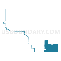
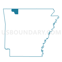
Osage Voting District, Carroll County, Arkansas
About
Outline

Summary
| Unique Area Identifier | 526066 |
| Name | Osage Voting District |
| County | Carroll County |
| State | Arkansas |
| Area (square miles) | 42.83 |
| Land Area (square miles) | 42.81 |
| Water Area (square miles) | 0.02 |
| % of Land Area | 99.95 |
| % of Water Area | 0.05 |
| Latitude of the Internal Point | 36.16490600 |
| Longtitude of the Internal Point | -93.37601890 |
Maps

Graphs
Select a template below for downloading or customizing gragh for Osage Voting District, Carroll County, Arkansas


Neighbors
Neighoring Voting District (by Name) Neighboring Voting District on the Map
- Carrollton Voting District, Carroll County, AR
- Dryfork Voting District, Carroll County, AR
- Liberty Voting District, Carroll County, AR
- Piney Voting District, Carroll County, AR
- Plumlee Voting District, Newton County, AR
- Summit Voting District, Boone County, AR
Top 10 Neighboring County Subdivision (by Population) Neighboring County Subdivision on the Map
- Carrollton township, Carroll County, AR (716)
- Summit township, Boone County, AR (556)
- Osage township, Carroll County, AR (418)
- Dry Fork township, Carroll County, AR (292)
- Osage township, Newton County, AR (238)
- Piney township, Carroll County, AR (226)
- Plumlee township, Newton County, AR (223)
- Liberty township, Carroll County, AR (158)
Top 10 Neighboring Unified School District (by Population) Neighboring Unified School District on the Map
- Harrison School District, AR (21,103)
- Berryville Public Schools, AR (10,893)
- Green Forest School District, AR (7,384)
- Jasper School District, AR (5,912)
- Alpena School District, AR (2,960)
Top 10 Neighboring State Legislative District Lower Chamber (by Population) Neighboring State Legislative District Lower Chamber on the Map
Top 10 Neighboring State Legislative District Upper Chamber (by Population) Neighboring State Legislative District Upper Chamber on the Map
Top 10 Neighboring 111th Congressional District (by Population) Neighboring 111th Congressional District on the Map
Top 10 Neighboring Census Tract (by Population) Neighboring Census Tract on the Map
- Census Tract 9505, Carroll County, AR (7,470)
- Census Tract 7904, Boone County, AR (6,019)
- Census Tract 1801, Newton County, AR (4,077)
Top 10 Neighboring 5-Digit ZIP Code Tabulation Area (by Population) Neighboring 5-Digit ZIP Code Tabulation Area on the Map
- 72601, AR (30,163)
- 72616, AR (10,441)
- 72740, AR (9,543)
- 72638, AR (7,186)
- 72611, AR (1,696)
- 72624, AR (594)